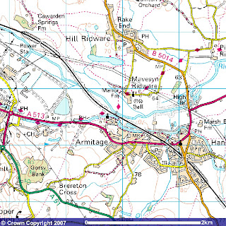
 On an older map of Mavesyn Ridware and surrounding area I noticed some intriguing waterways leading from the R. Trent into the grounds of the newly built power station at Armitage, but on this later map they've all but disappeared. Were they still there, I thought?
The ariel shots on Google Earth were no help, as this area fell in the 'blurry' zone and it just wasn't quite clear enough to see. I would have to go and investigate, and this was kayak territory...
 It wasn't going to be simple because there isn't easy access to the river here. Although a main road crosses the river at 'High Bridge' it is to my surprise, rather high! The route would have to be a little more convoluted. So, we ('we' being me and Jenny, she's a good sport and up for any expedition) launched our kayaks at the canal near Handsacre. Three quarters of a mile further west we had to portage the kayaks through this narrow tunnel under the railway, along the footbridge over the river, and then part way down the field. A 22kg boat starts to feel a bit heavy at this point, and now I've got to go back and fetch Jennys!
  Now on the R.Trent, we paddled upstream, under the footbridge and it wasn't long before I spotted a gap in the bank on my left. It wasn't far enough up to be anything to do with the power station, but needed to be checked out. Pushing through the reeds, a pleasant channel of water presented itself. This was fun. A short paddle later and...Ooh! Tunnels. Decision time. 1.) Do I go in? 2.)Left or right. Sticking the nose of the kayak in, I soon realised that the water level in the tunnel wasn't deep enough, and I couldn't get out and explore by foot because although the water was shallow, prodding with a paddle revealed nearly 5 foot of silt. Duly marked on my Gps, I retreated.
 Half a miles hard paddling against the current, the railway crosses the river. There used to be a weir here but has long ago disintegrated, leaving the fast flowing water strewn with boulders and stonework. Impossible to get a clean stroke for all the debris, we were forced to get out and 'line' the kayaks through here. Thankfully the water was low, but this stretch is treacherous after heavy rain as you can see from the height and amount of rubbish/trees wedged against the bridge footings!
 The river widened out, and it was not long before we came to the first channel. We were out of luck. It was narrow, fast flowing and interrupted by lots of little weirs. It was an outlet from the power station. What we needed to find was the inlet...
 A good three quarters of a mile further on we came across one. Oh no! It was gated off, all this way for nothing.
 Perseverance pays. Higher up, in the shadow of the cooling towers, was another channel. Someone has foolishly left the door open...
What a beautiful bit of waterway. High banks, clothed with reeds and flowers and spanned periodically by little access bridges. I was quite hopeful that we would be able to get right under the cooling towers..got my camera ready!
 Foiled at the last hour!! A gate, and locked! Beyond, an inviting body of water and the continuance of the channel. I would never know where it went...
 Foiled at the last hour!! A gate, and locked! Beyond, an inviting body of water and the continuance of the channel. I would never know where it went...


2 comments:
Maybe you should start on the other side of the gate next time. Anyhow, sounds like a fun day even with the gate.
Sounds tiring but fun.
Always love your photo's.
Better luck next time.
Post a Comment